


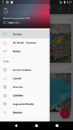


Beschreibung von Mobile Topographer GIS
The beloved choice of the professionals, Mobile Topographer ...meets... GIS.
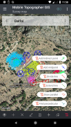
You can now perform a complete survey without any limitations into complexity or volume of data.
Try now Mobile Topographer GIS by using the three days free trial period. Just download the app and proceed with he subscription procedure. Although, you will be asked to provide billing information, you will NOT be charged before the end of the three days of the free trial period. You can cancel your subscription at any time during the three days trial period, free of charge. Charges will only occur, if at the end of the three days you still have an active subscription.
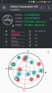
- Collect GNSS readings using increased accuracy (GPS, GLONASS, Galileo, Beidou, QZSS constellations supported).
- Connect your external GNSS receiver via mock locations and use Mobile Topogrpaher GIS as a processing unit.
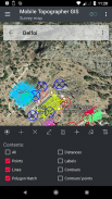
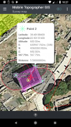
- Display data into WGS84 or you local projected CRS.
- Convert from WGS84 to local projected CRS and vice versa.
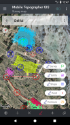
- Real time projection on map.
- *** NEW *** Custom image or WMS server as map background.
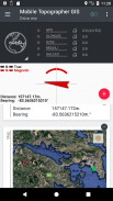
- Find a marked point in the real world by using "Drive me"
- Calculate Orthometric height on the fly using EGM model or local elevation grids where available.
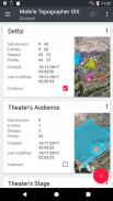
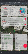
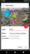
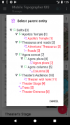
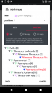
- Organize your work into Points - Shapes - Entities & Surveys. You can now create individual points, multi-point groups, multipart polylines, and multipart polygons with holes.
- Create a full drawing with as much details as you want.
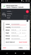
- *** NEW *** geodetic tools. Add indirect points via on of the following options: 1 point + Distance + Azimuth, 2 points + Distances + Select, 2 points + Azimuths, 3 points + Distances, Midpoint of line, Divide line, Extend line, Parallel line, Perpendicular to line.
- Nest your jobs, in any nesting level, to create a super-survey.
- Share data between jobs with active links.
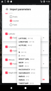
- Exchange jobs between your mobile device and your desktop computer, with import - export functions using all common formats .txt, .csv, .kml, .gpx, .dxf and Shape files (.shp - .shx - .dbf)
- Collaborate with your partners by exchanging and sharing from one point to complete jobs.
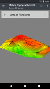
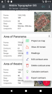
- Create the 3D terrain of an area by simply walking through it.
- Calculate contours and add them into your survey with lightning speeds.
- View a real 3D model directly into your device.
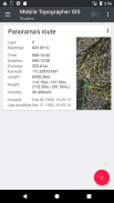
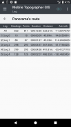
- Store a route with its data.
- Show GNSS satellites with signal info in both compass view or AR.
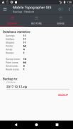
- Backup and restore your data using an SQL .db file.
Welcome to the era of mobile surveying...!
Find more about Mobile Topographer GIS in:
http://applicality.com/projects/mobile-topographer-gis/
Download the user's manual from:
http://applicality.com/app_documentation/web/MobileTopographerGIS_Manual.pdf
Die geliebte Wahl der Profis, Handy Topographer ... erfüllt ... GIS .
Sie können nun eine komplette Übersicht ohne Einschränkungen in der Komplexität oder das Volumen der Daten durchzuführen.
Versuchen Sie jetzt Mobil Topographer GIS durch die drei Tage kostenlose Probezeit verwenden. Laden Sie einfach die App und geht mit ihm Abonnement-Verfahren. Obwohl, werden Sie gefragt, Abrechnungsinformationen zur Verfügung zu stellen, werden Sie nicht vor dem Ende der drei Tage der kostenlosen Probezeit berechnet. Sie können Ihr Abonnement jederzeit während der drei Tage Probezeit kostenlos stornieren. Die Gebühren werden nur dann erfolgen, wenn am Ende der drei Tage, die Sie immer noch ein aktives Abonnement haben.
- GNSS Ablesungen Collect erhöhte Genauigkeit unter Verwendung von (GPS, GLONASS, Galileo, Beidou, QZSS Konstellationen unterstützt).
- Schließen Sie Ihren externen GNSS-Empfänger über simulierte Standort- und Mobil Topogrpaher GIS als eine Verarbeitungseinheit verwenden.
- Anzeige von Daten in WGS84 oder Sie lokale CRS projiziert.
- Konvertieren von WGS84 auf lokale CRS und vice versa projiziert.
- Echtzeit-Projektion auf der Karte.
- *** NEU *** Benutzerdefinierte Bild oder WMS-Server als Kartenhintergrund.
Finden Sie einen markierten Punkt in der realen Welt unter Verwendung von „Drive me“ -
- Berechnen Orthometrisch Höhe on the fly mit EGM-Modell oder lokale Erhöhung Gittern, sofern verfügbar.
Organisieren Sie Ihre Arbeit in Punkte - - Formen - Entities & Surveys. Sie können nun einzelne Punkte, Multi-Point-Gruppen, mehrteiliger Polylinien und mehrteiliger Polygone mit Löchern erstellen.
Erstellen Sie eine vollständige Zeichnung so viele Informationen wie Sie wollen -.
- *** NEU *** geodätische Werkzeuge. In indirekte Punkten über auf den folgenden Optionen: 1 Punkt + Entfernung + Azimuth, 2 Punkte + Entfernungen + Select, 2 Punkte + Azimute, 3 Punkte + Entfernungen, Mittelpunkt der Linie, Dividieren Linie, Extend Linie, Parallel Linie senkrecht zur Linie .
- Nest Ihrer Jobs in jeder Verschachtelungsebene, eine super-Umfrage zu erstellen.
- Gemeinsame Nutzung von Daten zwischen zwei Jobs mit aktiven Links.
- Austausch von Jobs zwischen Ihrem mobilen Gerät und Ihrem Desktop-Computer, mit dem Import - Export-Funktionen unter Verwendung aller gängigen Formate .txt, .csv, .kml, .gpx, .dxf und Form-Dateien (SHP - .shx - DBF)
- Arbeiten Sie mit Ihren Partnern durch den Austausch und von einem Punkt teilen Jobs abzuschließen.
Erstellen Sie das 3D-Gelände eines durch einfach durch sie zu Fuß -.
- Berechnen Konturen und fügen Sie sie in Ihre Umfrage mit blitzschnell.
- Sehen Sie ein echtes 3D-Modell direkt in Ihr Gerät.
- eine Route mit seinen Datenspeicher.
- anzeigen GNSS-Satelliten mit Signalinformationen in beide Kompass-Ansicht oder AR.
- Sicherung und Wiederherstellung Ihrer Daten eine SQL-Db-Datei.
Willkommen in der Ära der mobilen Vermessung ...!
Mehr zu Mobile Topographer GIS in:
http://applicality.com/projects/mobile-topographer-gis/
Laden Sie die Bedienungsanleitung aus:
http://applicality.com/app_documentation/web/MobileTopographerGIS_Manual.pdf


Mobile Topographer GIS – APK Informationen
APK Version: 6.0.15Paket: com.applicality.mobiletopographergisApps in derselben Kategorie
Das könnte dir auch gefallen...


